4등급 태풍 마와르에 대비한 괌 브레이스
Guam Braces for a Category 4 Typhoon Mawar
페이지 정보
작성자 Associated Press 작성일 23-05-23 00:49 댓글 0본문
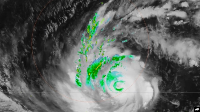
미국 국립 기상국이 제공한 이 레이더 이미지에서 5월에 괌 근처에서 태풍 마와르가 관측됩니다
In this radar image provided by the U.S National Weather Service, Typhoon Mawar is seen near Guam on May 22, 2023.
호놀룰루 —
Honolulu —
괌 주지사는 주민들에게 집에 머물 것을 촉구하고 태풍 마와르가 태평양의 미국 영토로 향하는 경로에서 강화됨에 따라 섬이 태풍 마와르로부터 직접적인 타격을 받을 수 있다고 경고했습니다.
Guam's governor urged residents to stay home and warned the island could take a direct hit from Typhoon Mawar as the storm strengthened on a path toward the U.S. territory in the Pacific.
루 레온 게레로 주지사는 유튜브 메시지를 통해 주민들에게 현지 시간으로 수요일 정오쯤 괌 남부를 강타할 수 있는 마와르에 대비해 침착할 것을 당부했습니다.
Governor Lou Leon Guerrero urged residents in a YouTube message to remain calm and prepare for Mawar, which the weather service said could hit the southern part of Guam around midday local time on Wednesday.
괌 티얀에 있는 국립 기상국의 수석 기상학자인 패트릭 돌은 AP통신에 "우리는 직접적인 타격을 입을 수도 있습니다,"라고 말했습니다. "우리가 직접적인 타격을 받지 않는다면, 그것은 매우 아슬아슬할 것입니다."
"We may take a direct hit," Patrick Doll, lead meteorologist for the National Weather Service in Tiyan, Guam, told The Associated Press. "If we don't take a direct hit, it's going to be very close."
기상청에 따르면 카테고리 3 폭풍의 중심은 화요일 괌 남동쪽 약 313.8km 부근에서 괌을 향해 시속 14.4~16km의 속도로 북서진했습니다.
The center of the Category 3 storm was about 313.8 kilometers southeast of Guam on Tuesday and moving northwest at 14.4 to 16 kph toward Guam, according to the weather service.
태풍은 시속 225km의 4등급 태풍으로 예상되어 20년 만에 가장 큰 피해를 줄 것이라고 기상 당국이 말했습니다.
It was expected to arrive as a 225 kph Category 4 typhoon, weather officials said, possibly delivering the biggest hit in two decades.
태풍은 "대규모 피해"를 일으킬 수 있다고 돌은 말했습니다.
The typhoon could cause "extensive damage," Doll said.
주지사는 괌을 오후 1시부터 봉쇄하겠다고 말했습니다. 화요일.
The governor said he would place Guam essentially in a lockdown effective 1 p.m. Tuesday.
"당신이 응급 구조자가 아닌 이상, 당신은 당신의 집을 떠나지 않습니다,"라고 Doll은 말했습니다.
"Unless you're a first responder, you do not leave your house," Doll said.
그는 화요일 아침에 폭풍의 외부 띠에서 비가 내리기 시작했다고 말했습니다.
Rain from the storm's outer bands was starting to fall Tuesday morning, he said.
보통 만조 때보다 1.82~3m 높은 폭풍 해일이 예상돼 최고 4.6m까지 오를 수 있습니다. 기상청은 화요일 오후부터 수요일까지 6~7.6미터의 위험한 파도와 함께 남향과 동쪽을 향한 암초를 따라 다음 날이나 이틀 동안 급격하게 파도가 형성될 것으로 예상했습니다.
A storm surge of 1.82 to 3 meters above the normal high tide was expected and could reach up to 4.6 meters. Surf was expected to build sharply in the next day or two along south- and east-facing reefs, with dangerous surf of 6 to 7.6 meters Tuesday afternoon into Wednesday, the weather service said.
월요일 섬의 식료품점과 철물점에서 사람들은 통조림, 물 상자, 발전기를 가득 실은 쇼핑 카트를 가지고 떠났다고 퍼시픽 데일리 뉴스가 보도했습니다.
At the island's grocery and hardware stores Monday, people were leaving with shopping carts full of canned goods, cases of water and generators, the Pacific Daily News reported.
괌 교육부는 화요일 긴급 대피소를 열 준비를 하고 있다고 KUAM이 보도했습니다.
The Guam Department of Education was preparing to open emergency shelters Tuesday, KUAM reported.
프란시스 10세 목사. 예수회 사제이자 데데도의 산타 바바라 교회의 보조 목사인 헤젤은 화요일 방문객들에게 문을 닫기 전에 병원에 있는 사람들을 방문하려고 노력하고 있었습니다.
The Rev. Francis X. Hezel, a Jesuit priest and assistant pastor at Santa Barbara Church in Dededo, was trying to visit people at the hospital before it closed to visitors Tuesday.
길을 떠나기 전에, 그는 모두가 폭풍을 견디기 위해 집을 준비하느라 바빴기 때문에 타이어에 공기 넣는 것을 도와줄 사람을 찾는 데 어려움을 겪었다고 그는 말했습니다.
Before hitting the road, he had trouble finding someone to help him put air in his tires because everyone was busy readying their homes to withstand the storm, he said.
"저는 교실에 살고 있습니다."라고 그가 말했습니다. "저는 돌풍이 창문을 부수지 않기를 바라며 창문을 닫는 중입니다. 최고를 위해 기도하는 것 같아요."
"I live in a rectory," he said. "I'm just closing the windows, hoping that the gusts don't bash them in. Praying for the best, I guess."
관계자들은 완전히 콘크리트 구조물이 아닌 주민들에게 안전을 위해 이동을 고려하라고 경고했습니다. 많은 집들은 나무와 주석으로 만들어졌습니다.
Officials warned residents who aren't in fully concrete structures to consider moving for safety. Many homes are made of wood and tin.
기상청은 화요일 아침 업데이트에서 "[카테고리] 4 태풍 강풍, 집중호우, 생명을 위협하는 폭풍 해일의 3중 위협이 괌과 로타에 모두 예상된다"고 밝혔습니다.
"The triple threat of a [category] 4 typhoon force winds, torrential rains and life-threatening storm surge are all expected for Guam and Rota," the weather service said in a Tuesday morning update.
북마리아나 제도의 미국 연방에 있는 로타 섬도 태풍 경보를 받고 있었다고 돌은 말했습니다. 마리아나 북부의 티니안과 사이판은 열대성 폭풍 경보를 받았습니다.
Rota, an island in the U.S. Commonwealth of the Northern Mariana Islands, was also under a typhoon warning, Doll said. Tinian and Saipan, in the northern Marianas, were under tropical storm warnings.
2018년 5등급 슈퍼 태풍 위투 이후 그 지역의 일부 사람들은 여전히 임시 대피소나 텐트에 있다고 돌은 지적했습니다.
Some people in those areas are still in temporary shelters or tents after Category 5 Super Typhoon Yutu in 2018, Doll noted.
괌은 5~7년마다 4~5등급의 타격을 받습니다. 돌은 "대자연은 최근까지 우리를 구해줬다"며 "마지막 직격탄은 2002년이었다"고 덧붙였다.“
"Guam takes a Category 4 or 5 hit every five to seven years. Mother Nature has spared us as of late," Doll said, adding that the last direct hit was in 2002. "So we are way overdue."
출처 : VOANews
댓글목록 0
등록된 댓글이 없습니다.