설명자: 인도네시아의 얕은 지진은 왜 그렇게 치명적이었을까요?
Explainer: Why Was Indonesia's Shallow Quake So Deadly?
페이지 정보
작성자 Associated Press 작성일 22-11-22 22:46 댓글 0본문
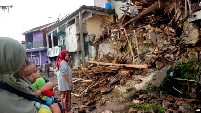
주민들이 11월 인도네시아 서자바 주 키안주르에서 월요일 지진으로 피해를 입은 집들을 조사하고 있습니다.
Residents inspect houses damaged by Monday's earthquake in Cianjur, West Java, Indonesia, Nov. 22, 2022.
자카르타, 인도네시아 —
Jakarta, Indonesia —
인도네시아의 주요 섬 자바에서 규모 5.6의 지진이 발생해 건물들이 무너지고 공포에 질린 주민들이 목숨을 건지는 바람에 260명 이상이 숨지고 수백 명이 다쳤습니다.
A 5.6 magnitude earthquake left more than 260 dead and hundreds injured as buildings crumbled and terrified residents ran for their lives on Indonesia's main island of Java.
인도네시아에서 가장 인구밀도가 높은 서자바 주와 수도 자카르타에서 남쪽으로 약 217km 떨어진 곳에 위치한 가장 큰 피해를 입은 도시인 키안주르에서는 화요일 아침에도 잔해에서 시신들이 계속해서 인양되었습니다. 많은 사람들이 여전히 실종 상태입니다.
Bodies continued to be pulled from the debris on Tuesday morning in the hardest-hit city of Cianjur, located in the country's most densely populated province of West Java and some 217 kilometers (135 miles) south of the capital, Jakarta. A number of people are still missing.
일반적으로 진도는 건물과 다른 구조물에 가벼운 손상을 입힐 것으로 예상되지만, 전문가들은 단층선에 가까운 곳, 지진의 얕음, 지진을 견딜 수 없는 불충분한 기반 시설 모두가 피해에 기여했다고 말합니다.
While the magnitude would typically be expected to cause light damage to buildings and other structures, experts say proximity to fault lines, the shallowness of the quake and inadequate infrastructure that cannot withstand earthquakes all contributed to the damage.
참고 항목: 인도네시아는 지진 생존자를 찾습니다.
SEE ALSO:
Indonesia Searches for Earthquake Survivors
다음은 지진에 대한 자세한 내용과 지진이 그렇게 큰 피해를 준 몇 가지 이유입니다.
Here's a closer look at the earthquake and some reasons why it caused so much devastation:
월요일의 지진은 "강한" 것으로 여겨졌습니까?
Was Monday's earthquake considered "strong"?
미국 지질조사국은 월요일 오후 늦게 발생한 지진의 규모는 5.6이며 깊이는 10킬로미터라고 발표했습니다.
The U.S. Geological Survey said the quake late Monday afternoon measured 5.6 magnitude and struck at a depth of 10 kilometers (6.2 miles).
이 정도 규모의 지진은 일반적으로 잘 구축된 인프라에 광범위한 피해를 입히지 않습니다. 그러나 이 기관은 "피해가 발생할 규모는 하나도 없다"고 지적합니다. 지진으로부터의 거리, 당신이 어떤 종류의 흙 위에 있는지, 건물 건설"과 같은 다른 변수들에 따라 다릅니다.
Quakes of this size usually don't cause widespread damage to well-built infrastructure. But the agency points out, "There is not one magnitude above which damage will occur. It depends on other variables, such as the distance from the earthquake, what type of soil you are on, building construction" and other factors.
인도네시아에서는 이슬람 기숙학교와 병원, 기타 공공시설 등 수십 채의 건물이 파손됐습니다. 또한 도로와 다리가 파손되었고, 지역의 일부가 정전을 겪었습니다.
Dozens of buildings were damaged in Indonesia, including Islamic boarding schools, a hospital and other public facilities. Also damaged were roads and bridges, and parts of the region experienced power blackouts.
그렇다면 지진은 왜 그렇게 많은 피해를 입혔을까요?
So why did the quake cause so much damage?
전문가들은 단층선과의 근접성, 지진의 깊이, 그리고 내진 방법을 사용하여 건설되지 않은 건물들이 파괴의 요인이라고 말했습니다.
Experts said proximity to fault lines, the depth of the temblor and buildings not being constructed using earthquake-proof methods were factors in the devastation.
인도네시아 욕야카르타에 있는 Universitas Gadjah Mada의 조교수인 Gayatri Marliyani는 "지진은 중간 규모였지만, 지진은 지표면에 가까웠고, 내륙에 위치해 사람들이 사는 곳에 가까웠습니다,"라고 말했습니다. "에너지는 여전히 큰 흔들림을 일으킬 수 있을 정도로 컸고, 이로 인해 손상을 입었습니다."
"Even though the earthquake was medium-sized, it (was) close to the surface ... and located inland, close to where people live," said Gayatri Marliyani, an assistant geology professor at Universitas Gadjah Mada, in Yogyakarta, Indonesia. "The energy was still large enough to cause significant shaking that led to damage."
가장 큰 피해를 입은 지역은 알려진 여러 단층에 가깝다고 말리야니는 말했습니다.
The worst-affected area is close to several known faults, said Marliyani.
단층은 지구의 표면을 형성하는 바위에 긴 균열이 있는 곳입니다. 이 단층들 중 하나에서 지진이 일어나면, 단층의 한쪽에 있는 바위가 다른 단층에 대해 미끄러집니다.
A fault is a place with a long break in the rock that forms the surface of the earth. When an earthquake occurs on one of these faults, the rock on one side of the fault slips with respect to the other.
"이 지역은 자바의 다른 지역과 비교했을 때 아마도 가장 많은 내륙 단층을 가지고 있을 것입니다," 라고 Marliyani가 말했습니다.
"The area probably has the most inland faults compared to the other parts of Java," said Marliyani.
그녀는 몇몇 잘 알려진 단층들이 그 지역에 있지만, 잘 연구되지 않은 다른 많은 활성 단층들이 있다고 덧붙였습니다.
She added that while some well-known faults are in the area, there are many other active faults that are not well studied.
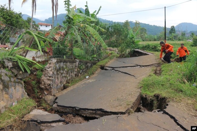
구조대원들이 11월 인도네시아 서자바 주 키안주르에서 월요일 지진으로 심하게 파손된 도로를 항해하고 있습니다.
Rescuers navigate through a road badly damaged during Monday's earthquake, in Cianjur, West Java, Indonesia, Nov. 23, 2022.
이 지역의 많은 건물들도 내진 설계로 지어지지 않았고, 이것이 더 큰 피해를 입혔다고 인도네시아 지질학 연구소의 지진 지질 전문가인 대니 힐만 나타위자가 말했습니다.
Many buildings in the region are also not built with quake-proof designs, which further contributed to the damage, said Danny Hilman Natawidjaja, an earthquake geology expert at the Indonesian Institute of Sciences Geotechnology Research Center.
"이것은 이 크기와 깊이의 지진을 훨씬 더 파괴적으로 만듭니다," 라고 그가 말했습니다.
"This makes a quake of this size and depth even more destructive," he said.
인도네시아는 보통 이런 지진이 있나요?
Does Indonesia usually have earthquakes like this?
2억 7천만 명 이상의 인구가 살고 있는 이 나라는 "불의 고리"로 알려진 태평양 분지의 화산 호와 단층선에 위치하기 때문에 지진, 화산 폭발, 쓰나미가 자주 강타합니다. 이 지역은 약 40,000 킬로미터 (25,000 마일)에 걸쳐 있고 세계 지진의 대부분이 발생하는 곳입니다.
The country of more than 270 million people is frequently struck by earthquakes, volcanic eruptions and tsunamis because of its location on the arc of volcanoes and fault lines in the Pacific Basin known as the "Ring of Fire." The area spans some 40,000 kilometers (25,000 miles) and is where a majority of the world's earthquakes occur.
인도네시아의 많은 지진들은 경미하고 피해를 거의 내지 않습니다. 하지만 치명적인 지진도 있었습니다.
Many of Indonesia's earthquakes are minor and cause little to no damage. But there have also been deadly earthquakes.
지난 2월 서수마트라 주에서 규모 6.2의 지진이 발생해 최소 25명이 숨지고 460여 명이 다쳤습니다. 2021년 1월 서술라웨시 지방에서 규모 6.2의 지진이 발생해 100명 이상이 사망하고 6,500명 가까이 부상을 입었습니다.
In February, a magnitude 6.2 earthquake killed at least 25 people and injured more than 460 in West Sumatra province. In January 2021, a magnitude 6.2 earthquake killed more than 100 people and injured nearly 6,500 in West Sulawesi province.
2004년에 강력한 인도양 지진과 쓰나미가 12개국에서 230,000명의 사람들을 죽였고, 그들 중 대부분은 인도네시아에 있었습니다.
A powerful Indian Ocean quake and tsunami in 2004 killed 230,000 people in a dozen countries, most of them in Indonesia.
출처 : VOANews
댓글목록 0
등록된 댓글이 없습니다.