National Geographic Information Administration says North Korea's Geomdeok Mine is rich in resources but 'development' is not working properly
페이지 정보
작성자 박승혁 작성일 22-08-19 02:30 댓글 0본문
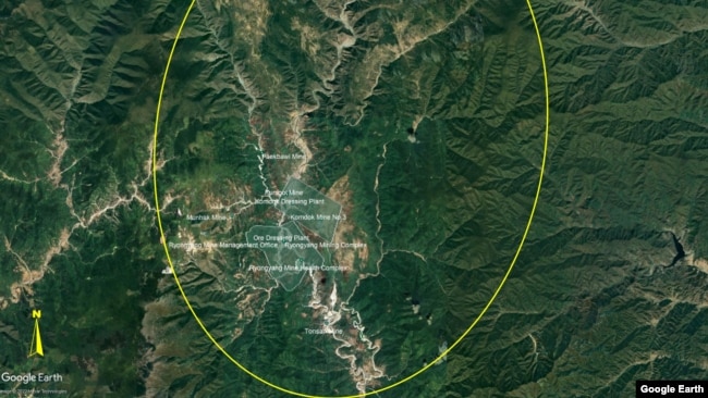
Satellite images of North Korea's Gumdeok mine were published in the National Geographic Intelligence Agency (NGA) under the Pentagon.
The U.S. National Geographic Information Administration says the mineral-rich Geomdeok District development plan is likely to degenerate into an "empty promise." It is pointed out that the North Korean authorities are focusing only on "show" construction instead of investing in essential infrastructure. Reporter Park Seung-hyuk reports.
In a report titled "North Korea Gumdeok Mine: Empty Promise?" published on the 15th, the National Geographic Intelligence Agency (NGA) under the U.S. Department of Defense said that the mining district in Gumdeok, South Hamgyong Province, North Korea, is not being developed properly despite its potential.
Located in the northern part of South Hamgyong Province, the mining district is North Korea's largest mining area, home to more than 50 mines, including Geomdeok, Ryongyang and Daeheung.
According to the report, the area is rich in lead, silver, and magnesium, especially zinc, with an estimated 266 million tons of reserves, the largest in East Asia.
[National Geographic Intelligence Agency report] "북한은 세계에서 가장 주요한 아연 생산국 중 하나가 될 수 있는 능력을 가지고 있습니다. 아연은 광범위한 용도를 가지고 있어 가치 있는 상품입니다."
The report said zinc is a valuable raw material because it can be used in a variety of products, and North Korea has the capacity to become one of the world's largest zinc producers.
In fact, in 2020, Chairman of the State Affairs Commission Kim Jong-un visited Geomdeok District, which was damaged by Typhoon Maisak, and ordered the restoration project, saying, "We will transform it into a national example mountainous city after Samjiyeon City."
However, the report points out that the two-year project to restore Geomdeok district has focused on housing construction, and investment in mining infrastructure such as mines, roads and railroads that will actually develop the Geomdeok district is not noticeable.
[National Geographic Intelligence Agency Report] "그러나 광산에 대한 실제 투자와 새로운 도로나 철도 노선과 같은 지원 기반 시설, 즉 콤독을 진정으로 개선하려는 노력은 분명하지 않았습니다."
Based on satellite images of the region, the report explained that North Korean authorities quickly built apartments and other housing facilities to complete the "mountain city" ordered by Chairman Kim Jong-un.
But he said he wondered if the flood-prone area was properly equipped with the necessary flood control facilities.
[National Geographic Intelligence Agency report] "하지만 1년도 채 지나지 않아 봄 장마에 이어 길거리에서 고인 물이 관측되었고, 이는 심한 폭풍에 직면하여 향후 홍수의 위험을 예고하고 있습니다. 그럼에도 불구하고, 가시적인 완화 노력이 이루어지지 않고 이 지역에 추가 주택이 계속 추가되고 있습니다."
In the spring of 2021, less than a year after Typhoon Maisak swept away, the road has already been seen overflowing, which indicates the possibility of flood damage in the event of a strong typhoon.
It also added that new housing complexes continue to be added without any visible flood preparedness.
As a result, the report asked whether North Korea is really serious about the revival of the Gumdeok district, pointing out that more investment is needed to maximize the potential of the mines in the area.
[National Geographic Intelligence Agency report] "콤독 지역은 막대한 자원을 보유하고 국가에 잠재력을 창출하고 있지만, 이 지역이 발전한 지형과 방식은 엔지니어링, 인프라 및 장비에 대한 심각한 투자 없이 홍수 방지와 폭풍 피해를 피할 수 없는 현실로 만듭니다."
Considering the topography and past development forms of Geomdeok District, flood control measures and typhoon damage are inevitable without serious investment in development, infrastructure, and equipment.
The report concluded that North Korea is not in a situation to carry out large-scale national development projects carefully, and that the development of Gumdeok District is likely to end with an "empty promise" because it is difficult to even properly construct due to chronic power shortages.
[National Geographic Intelligence Agency Report] "에너지 인프라에 대한 변화가 운영 능력을 높이고 광부와 그 가족의 삶의 질을 향상시키겠다는 약속의 핵심 지표가 되겠지만, 지난 10년 동안 촬영된 이미지는 이 지역의 발전을 거의 보여주지 않습니다."
The report also said that if there is a change in the energy supply infrastructure in the region, it can be seen as an indicator of North Korea's commitment to improving the quality of life for miners' families, but based on satellite images taken over the past 10 years, there has been little progress in this field.
I'm Park Seunghyuk of VOA News.
출처 : VOA한국
댓글목록 0
등록된 댓글이 없습니다.